Mount Jordan - 10063' and The General - 10329'
Location: 44.48337°N, 114.8028°W
Stats
Date: 06/28/2009
Distance: 8.7 miles
Elevation gain: 3500'
Class (difficulty): 2+
Time: 7 hours
Range: Salmon River
Prominence: 1909' for The General and 643' for Mount Jordan
Partner(s): Zach
Report:
I had an unexpected day to get out in the mountains and I had been looking into a new area around Bonanza. There are lots of inviting peaks in that area, but I finally figured a ascent of both Mount Jordan and The General in the Salmon River Range would be scenic and reasonable. So I contacted Zach looking for someone to go with. Zach was on his way back from doing Smiley Mountain with Splattski (Splattski was my next call). I didn’t think he would be interested after a big day and big drive to Smiley, but he was a bit interested. As we texted back and forth, he became more and more interested. Zach finally committed around 10:30pm with a planned 5:30am start. Talk about last minute plans! Splattski was not looking forward to a second straight early morning, so he passed on the trip.
Mount Jordan is pointy peak located about 5 miles north of Bonanza (an old mining town 15 miles from Stanley). A jeep road reaches about 9200’ on its southeast side. I wasn’t sure how far we could drive on this jeep road that branched off the Loon Creek Summit road. Our plan was to follow this road to its end and then scramble up the south ridge of the peak. From the top of Mt. Jordan, we would hit The General via the connecting ridge line.
It turned out that we were able to follow the jeep road about half a mile to the first creek crossing. We didn’t feel we could make it through, so we stopped here. This was cool, as it saved us 300 feet of gain. We found a unimproved campsite just before the creek crossing and parked the vehicle. We set off hiking on the jeep trail from 7700’ on a blue bird day.
After only hiking about 15 minutes, we started hitting snow patches at 8000’. This surprised me as it was almost July! At around 8100’ the snow patches were deep, but off in the trees and not on the road. We followed the steep road to about 9000’ where we took our first break. This was also the first point where the snow completely covered the road.
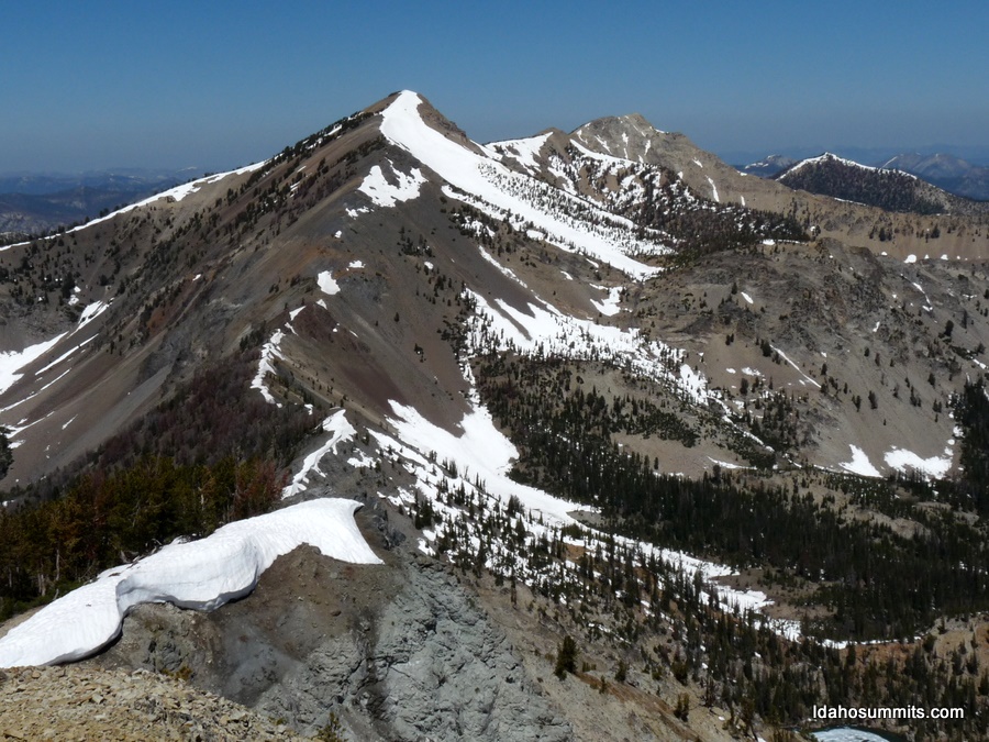
After our break we continued to follow the road (where visible) and made it above the tree line to a basin with views of the saddle just south of Mount Jordan and a sign for Ligtning Creek Trailhead buried in the snow. The snow here was sun-cupped, which I had only seen on Mount Whitney prior to this. We headed toward the saddle on snow and off-trail terrain until we found a trail that took us to the saddle. Once on the saddle, we took the south ridge to the top of Mount Jordan. The south ridge is very easy to follow and has no obstacles. The top of Mount Jordan is tiny and had incredible views in all directions. We could see the Sawtooths, White Clouds, Boulders, Lemhis, Lost Rivers… even able to pick out Borah, Bell, and other peaks. The views west to the Tango peaks were fantastic.
From the top of Mt Jordan we now set our targets on The General to our northwest. We could see the whole ridge leading over to it and decided it was a go. We descended on goat trails and over drifts to get to the saddle at 9500’. I was a bit shocked as I looked up at what had appeared to be a gentle ridge and was now looking a lot steeper from this prospective. We headed up, the terrain was stable except in one spot at around 9700’ to 9800’. However on descent, we found that we could have avoided that on the east side of the ridge. The higher we got on the ridge, the less steep it became, until it was an easy stroll over the final 200’. As we popped onto the summit, we were rewarded with incredible views of Mystery Lake, as the northeast face of The General drops quickly down to the lake. We spent a long time pointing and trying to identify the hundreds of peaks we could see. After pictures, sight seeing, texting our wifes, and signing in the register it was time to head down.
The best plan we could come up with for the way down was to re-ascend Mount Jordan. The 500’ of climbing that required didn’t sound like fun, but was the best route we knew of. So we sped down The General and back to the 9500’ saddle. We worked our way up the goat trails to about 9700’. Here I noticed a trail heading across the southwest face of Mount Jordan, instead of towards the summit. I spoke with Zach and we agreed to follow it, neither of us expecting it to do what we wanted and lead us to the the saddle south of Jordan and save us 300’ of climbing. As we followed the trail it kept heading that way and eventually lead us right to the saddle. This saved us gain and distance. From the saddle, we quickly headed back to the vehicle. After bagging 2 peaks, a beer at the trailhead, and dinner in Stanley we were feeling pretty good! Great day to be in the mountains.
Getting There:
Head toward Challis on ID 75 from Stanley. Drive 13 miles east, and turn north at Sunbeam onto Yankee Fork road. Follow the road 8 miles to Bonanza. Just past Bonanza, the road forks. The north (left) fork goes to Loon Creek Summit along Jordan Creek... take this fork. Follow the road 5.9 and turn left onto the jeep trail shown on the quad.
|
|
|