RockyMountainSummits.com Home  |  My Peak List  |  Message Board  |  Contact Me  |  View the Guestbook  |  Sign the Guestbook


Proctor Mountain - 7,798 feet


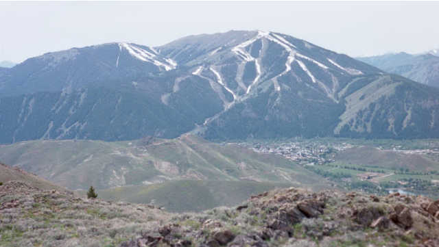
The view of Baldy Mountain and Sun Valley from the top.

Trip Report (May 2001):
I was impressed with the views of the Sun Valley area and Baldy Mountain from the top. However, bigger mountains block the views most directions and Proctor is not much of a peak. It is a pleasant, early-season hike though.

Trip stats:
Time: 4 hours
Length: 6 miles
Elevation Gain: 1,800 feet
Class (difficulty): 2

Directions:
Drive to Ketchum and turn east on Trail Creek road. After about 2 miles, you will see on small sign on the right hand side of the road for the "Trail Creek Cabin". Turn right and park in the large lot just off the road.

Route:
Walk down the road to the Trail Creek cabin. Head west around the cabin and across the bridge. Just after the bridge you will meet a road at the base of a hill. From here you have two options. You can head left and follow the trail that appears after a couple of hundred feet. This trail soon begins to switchback up a forested, then barren slope. Once the switchbacks end, the trail asends a ridge. After about 1/3 of a mile on the ridge, a trail intersects, keep heading up at this junction. The trail heads straight up, then angles across a hill on its west side to a saddle. From the saddle, the trail turns west and after a few hundred yards, reaches another saddle, between Proctor and another peak. From here, traverse across the sagebrush, through the trees and to the top of Proctor.

Update!
Here is an update from Gene Cheston about the trailhead:
So that you can know the current state of affairs, I am writing to tell you that the Sun Valley Company has cut two new access routes that ultimately join that dirt road at the bottom of a hill (and well behind the Trail Creek Cabin).

While it used to be true that you could access Proctor Loop in the manner that you include in your web site, however, the SV Co. did not want parkers and walkers going through the cabin area as they stage weddings and functions in the space around the cabin.

The shortest route to Proctor Loop is to drive in the direction of trail creek cabin, however, 500 yards or so before TC cabin, there is a sign for the Hemingway Memorial. There is space for parking.

The other alternative (and the first one that SV co provided) route mandates a longer hike and was very unpopular with the local hikers because it added 1 1/2 miles to the hike along the flats west of TC cabin. SV put in a parking lot and built a fancy steel bridge for access to the bench area to the west of the cabin and the Proctor Loop. Though the bridge is used, it is mostly used, I think, by others than those who just want to do the Loop.

The alternative route is to turn right on the road at the base of the hill past the bridge. Follow the road southwest until you reach a signed trailhead for "Proctor Mountain". Follow the trail along a creek until it switchbacks up to meet the previously mentioned trail atop a ridge. Follow the previous directions to reach the top of Proctor Mountain.


Please send comments, suggestions, and questions to dan@idahosummits.com.
© 2001 All Rights Reserved RockyMountainSummits.com